Shop
Showing 121–144 of 183 results
-
Uncategorized
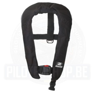
LIFEJACKET BALTIC WINNER 150 Zip
A 150N inflatable lifejacket from Baltic with manual gas inflation.
The Baltic Winner inflatable lifejacket is of minimal size so that you hardly know you are wearing it. Yet, when inflated it has up to 50% more buoyancy than traditional lifejackets. This is simply the most elegant solution to give maximum safety in minimal form.
To operate the manual valve you simply pull the toggle on the right hand side of the jacket downwards with a jerk and the bladder will start to inflate immediately. The outer cover features a zip closure which breaks open to allow smooth deployment of the air bladder and can be easily repacked.
Size: 40-150kg weight.
SKU: WINZIP150M-BL -
LightSpeed, LightSpeed, Pilot Headsets
LightSpeed – Zulu.3 ANR Headset
LightSpeed – Zulu.3 ANR Headset
Lightspeed Delta Zulu® is built for your mission with safety, control, and comfort in mind. Our newest headset includes Lightspeed’s best ANR to date, with the superior comfort and durability you expect from a Zulu, while also introducing groundbreaking new technologies that could save the lives of both pilots and passengers.
SKU: LS-Z3-ANR -
VFR Charts
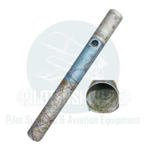
Low Air VFR Belgium (Plano- Laminated) 2026
The new 2026 version of the Belgium Low Air 1:250.000 chart, the reference for VFR flying across Belgium, contains all information relevant to VFR pilots, overlayed on the Belgian topographical chart. The airspace changes dated from March 3rd 2026, like the new Restricted Areas around the harbors of Antwerp, Ghent and Zeebrugge, EBR20 (Brasschaat) & EBR21 (North Sea), reporting point Duffy are all included…
This chart is available in 2 versions: Printed on 1 sheet, recto/verso – North and South – for easy cockpit management when flying between North and South areas; available in paper and in laminated form
It contains vital information about Belgian Airspace structure and topography:
- VFR reporting points
- Civil and Military airports with name, location identifier and frequencies, length and orientation of the runway(s), information about Direction Finding (VDF) and location of traffic pattern
- Designated airspace location, dimensions, vertical extent and airspace class.
- FIS sectors with frequencies
- Fields for hang-gliders, soaring, ULM…
- Radio Navigation beacon information (including VOR, DME, NDB, TACAN and combinations) with name, frequency and Morse code identifier
- Obstacles and elevation figures
- Isogonals
- Highways (with name), streets, railways, rivers, woods (with multi-coloring to display forest imprint and shading)
- Etc.
On the side, you can find a legend with more helpful information, like an overview of the Belgian airspace structure, ATIS and VOLMET frequencies, symbol interpretation, etc.
Specifications
- Scale: 1:250.000
- Edition: 2026
- Date of publication: May 2026( ED 35-IGNB – 2026)
- Available from 09-06-2026
SKU: VTAIR.0002.00.35-LAM -
VFR Charts
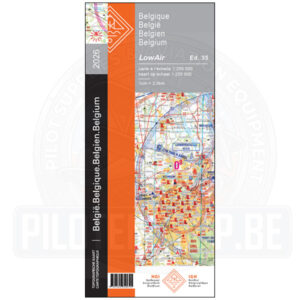
Low Air VFR Belgium (Plano) 2026
The new 2026 version of the Belgium Low Air 1:250.000 chart, the reference for VFR flying across Belgium, contains all information relevant to VFR pilots, overlayed on the Belgian topographical chart. The airspace changes dated from March 3rd 2026, like the new Restricted Areas around the harbors of Antwerp, Ghent and Zeebrugge, EBR20 (Brasschaat) & EBR21 (North Sea), reporting point Duffy are all included…
This chart is available in 2 versions: Printed on 1 sheet, recto/verso – North and South – for easy cockpit management when flying between North and South areas; available in paper and in laminated form
It contains vital information about Belgian Airspace structure and topography:
- VFR reporting points
- Civil and Military airports with name, location identifier and frequencies, length and orientation of the runway(s), information about Direction Finding (VDF) and location of traffic pattern
- Designated airspace location, dimensions, vertical extent and airspace class.
- FIS sectors with frequencies
- Fields for hang-gliders, soaring, ULM…
- Radio Navigation beacon information (including VOR, DME, NDB, TACAN and combinations) with name, frequency and Morse code identifier
- Obstacles and elevation figures
- Isogonals
- Highways (with name), streets, railways, rivers, woods (with multi-coloring to display forest imprint and shading)
- Etc.
On the side, you can find a legend with more helpful information, like an overview of the Belgian airspace structure, ATIS and VOLMET frequencies, symbol interpretation, etc.
Specifications
- Scale: 1:250.000
- Edition: 2026
- Date of publication: May 2026( ED 35-IGNB – 2026)
- Available from 09-06-2026
SKU: VTAIR.0002.00.35 -
VFR Charts
Low Air VFR Belgium (Ruffed – Laminated) 2026
The new 2026 version of the Belgium Low Air 1:250.000 chart, the reference for VFR flying across Belgium, contains all information relevant to VFR pilots, overlayed on the Belgian topographical chart. The airspace changes dated from March 3rd 2026, like the new Restricted Areas around the harbors of Antwerp, Ghent and Zeebrugge, EBR20 (Brasschaat) & EBR21 (North Sea), reporting point Duffy are all included…
This chart is available in 2 versions: Printed on 1 sheet, recto/verso – North and South – for easy cockpit management when flying between North and South areas; available in paper and in laminated form
It contains vital information about Belgian Airspace structure and topography:
- VFR reporting points
- Civil and Military airports with name, location identifier and frequencies, length and orientation of the runway(s), information about Direction Finding (VDF) and location of traffic pattern
- Designated airspace location, dimensions, vertical extent and airspace class.
- FIS sectors with frequencies
- Fields for hang-gliders, soaring, ULM…
- Radio Navigation beacon information (including VOR, DME, NDB, TACAN and combinations) with name, frequency and Morse code identifier
- Obstacles and elevation figures
- Isogonals
- Highways (with name), streets, railways, rivers, woods (with multi-coloring to display forest imprint and shading)
- Etc.
On the side, you can find a legend with more helpful information, like an overview of the Belgian airspace structure, ATIS and VOLMET frequencies, symbol interpretation, etc.
Specifications
- Scale: 1:250.000
- Edition: 2026
- Date of publication: May 2026( ED 35-IGNB – 2026)
- Available from 09-06-2026
SKU: VTAIR.0002.PP.35-LAM -
VFR Charts
Low Air VFR Belgium (Ruffed) 2026
The new 2026 version of the Belgium Low Air 1:250.000 chart, the reference for VFR flying across Belgium, contains all information relevant to VFR pilots, overlayed on the Belgian topographical chart. The airspace changes dated from March 3rd 2026, like the new Restricted Areas around the harbors of Antwerp, Ghent and Zeebrugge, EBR20 (Brasschaat) & EBR21 (North Sea), reporting point Duffy are all included…
This chart is available in 2 versions: Printed on 1 sheet, recto/verso – North and South – for easy cockpit management when flying between North and South areas; available in paper and in laminated form
It contains vital information about Belgian Airspace structure and topography:
- VFR reporting points
- Civil and Military airports with name, location identifier and frequencies, length and orientation of the runway(s), information about Direction Finding (VDF) and location of traffic pattern
- Designated airspace location, dimensions, vertical extent and airspace class.
- FIS sectors with frequencies
- Fields for hang-gliders, soaring, ULM…
- Radio Navigation beacon information (including VOR, DME, NDB, TACAN and combinations) with name, frequency and Morse code identifier
- Obstacles and elevation figures
- Isogonals
- Highways (with name), streets, railways, rivers, woods (with multi-coloring to display forest imprint and shading)
- Etc.
On the side, you can find a legend with more helpful information, like an overview of the Belgian airspace structure, ATIS and VOLMET frequencies, symbol interpretation, etc.
Specifications
- Scale: 1:250.000
- Edition: 2026
- Date of publication: May 2026( ED 35-IGNB – 2026)
- Available from 09-06-2026
SKU: VTAIR.0002.PP.35 -
Fuel, Maintenance & Accessories, Pilot Equipment
Nuova rade – Hose pump, manual suction Ø12,5 – Transparent
 Fuel, Maintenance & Accessories, Pilot Equipment
Nuova rade – Hose pump, manual suction Ø12,5 – Transparent
Nuova rade – Hose pump, manual suction Ø12,5 – Transparent
This corrugated hose pump is great to outfit your airplane for optimum customization and maintenance.
Allows quick and safe transfer of liquids from one container to another.
High quality and durable PVC material.
Suitable for gasoline, diesel, water.SKU: PUMP10 -
Fuel, Maintenance & Accessories, Pilot Equipment
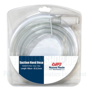
Nuova rade – Hose pump, manual suction Ø22,5 – Transparent
 Fuel, Maintenance & Accessories, Pilot Equipment
Nuova rade – Hose pump, manual suction Ø22,5 – Transparent
Nuova rade – Hose pump, manual suction Ø22,5 – Transparent
This corrugated hose pump is great to outfit your airplane for optimum customization and maintenance.
Allows quick and safe transfer of liquids from one container to another.
High quality and durable PVC material.
Suitable for gasoline, diesel, water.SKU: PUMP30 -
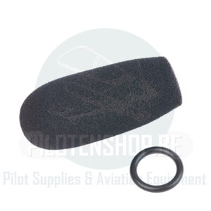
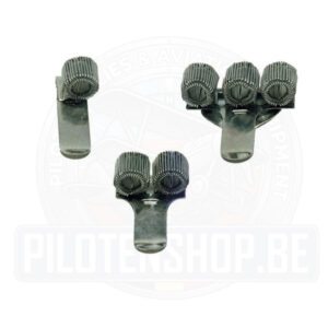
Asa, Cockpit Accessories, Cockpit Accessories, Pilot Equipment, Pilot Tools
Pen and Pencil Clips
Pen and Pencil Clips
Expanding spring-steel pen and pencil holders featuring a secure retaining clip, available in single, double, or triple loop designs.
Perfectly suited for attachment to flight case pockets, map folders, aircraft interiors, and more.SKU: ASA-KIT-FIRST+-1 -
Gift Card
Pilotenshop – Gift Voucher
Finding the right gear for a pilot, student pilot, or aviation enthusiast can be tricky.
With so many specialized tools, headsets, and accessories to choose from, why not let them pick exactly what they need?Take the guesswork out of gifting with the Pilotenshop.be Gift Voucher—the ultimate boarding pass to our entire online store!
SKU: GIFT_001


Recommended Products
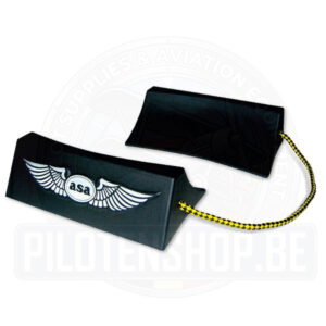
ASA® – Wheel Chocks
ASA® – Wheel Chocks
ASA Wheel chocks keep aircraft securely parked by preventing the tires from rolling.
These tire stops keep the aircraft securely parked. A pair of black molded plastic wheel stops are connected with 22″ bright yellow and black braided nylon rope that won’t rot or retain water. The bottom cleats keep aircraft securely parked, and the concave design fits any aircraft tire. One pair is needed for each wheel. Made in Korea. Lightweight; 7-3/4″ x 2-1/2″ x 4-1/2″.
Pen and Pencil Clips
Pen and Pencil Clips
Expanding spring-steel pen and pencil holders featuring a secure retaining clip, available in single, double, or triple loop designs.
Perfectly suited for attachment to flight case pockets, map folders, aircraft interiors, and more.
Nuova rade – Hose pump, manual suction Ø12,5 – Transparent
Nuova rade – Hose pump, manual suction Ø12,5 – Transparent
Nuova rade – Hose pump, manual suction Ø12,5 – Transparent
This corrugated hose pump is great to outfit your airplane for optimum customization and maintenance.
Allows quick and safe transfer of liquids from one container to another.
High quality and durable PVC material.
Suitable for gasoline, diesel, water.
Nuova rade – Hose pump, manual suction Ø22,5 – Transparent
Nuova rade – Hose pump, manual suction Ø22,5 – Transparent
Nuova rade – Hose pump, manual suction Ø22,5 – Transparent
This corrugated hose pump is great to outfit your airplane for optimum customization and maintenance.
Allows quick and safe transfer of liquids from one container to another.
High quality and durable PVC material.
Suitable for gasoline, diesel, water.